Posted on 10/07/2016 by Chris Stevenson
I have been rogaining more than 20 years, but I have never tried a NavShield until now. Julian, my regular rogaining partner suggested we “have a go” at this year’s event.
For those of you who are not familiar with the NavShield its purpose is to train emergency services personnel in the art of bush navigation so they can be of assistance in a bush rescue.
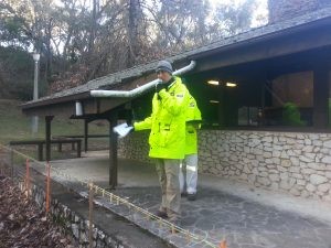
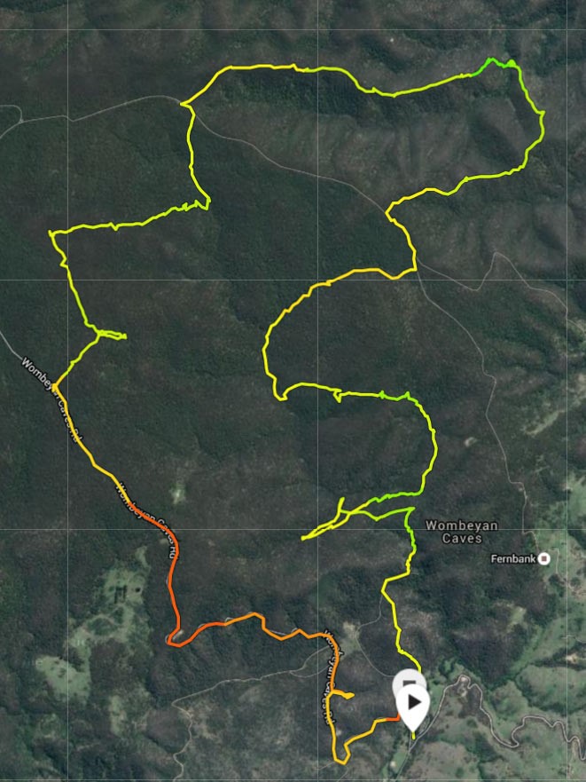
The NavShield includes a division for rogainiers to join in, using rogaining rules. This is key, because all of the other divisions have to take enough gear to be self-sufficient over night, including a sleeping bag. This year’s event was held at Wombeyan Caves and the very last thing I wanted to do was carry a pack full of camping gear up and down the mountains surrounding Wombeyan Caves. The other key difference with the Navshield is that you have to mark your own controls on the map. You are given a map and a set of co-ordinates which you use to mark controls on the map yourself.
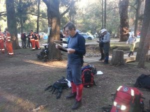
I confess that I wasn’t really looking forward to marking my own controls on the map. It just sounded like hard work, but actually it was worse than that. It was about 8 degrees and windy and maps were not available for collection until 6pm. Having collected our maps, Julian and I spent well over an hour marking controls on our maps out in the open, in the cold. It was definitely glove weather but marking maps with gloves on is too difficult so it was better to risk hypothermia for the sake of mapping accuracy. Bear in mind that every millimetre mistake in marking a control would be 25 metres of mountainous thick bush on the ground, so a 1 cm mistake could cost a lot of time.
The other thing to note about the map, was that it was not a very good print. It was very hard to see the creeks on the map. The blue lines were very thin and very faint and very hard to read. These thin and hard to read lines represented huge chasms in real life, so not being able to see them properly was less than ideal. In fact a couple of times during the event Julian and I had navigational disagreements because he could see a faint blue line on the map that I couldn’t.
Also on the subject of maps, because the intention of the NavShield is to train rescue services in bush navigation they use an unaltered base map. So if the base map is wrong, bad luck. Julian and I found this out the hard way. At the end of the event we left ourselves 40 minutes to get a 50 pointer near the hash house, which relied on us using a trail clearly marked on the map, but did not exist in real life. The net result was that we got within metres of the control but due to time pressure we had to turn around and sprint home empty handed.
There were two events on offer, the 10 hrs 45 min event (8:45am to 7:30pm ) or 29 hrs 15 mins event (8:45am Sat to 2:00pm Sun). Julian and I decided to do the 29 hours event. If we had to drive all the way to and from Wombeyan Caves and camp, we may as well make a full weekend of it. Julian and I had planned to take the gentleman’s approach to the 29hr event by going out for 12 hours and coming back to the hash house to have a good night’s sleep in a tent and then get up early and do some more on Sunday morning. The problem with this gentlemanly approach to the event was that this meant that we needed enough points near the hash house so we did not walk to and from the hash house empty handed. So we were a bit disappointed to find that the hash house was on the SE corner of the map and we would do a lot of walking to and from the hash house with few controls.
The first 12 hours went well with no real navigational mistakes. In fact, Julian and I were about to make a serious navigational error when along came Ted Woodley and his team and it was clear from the direction they came from that we were about to start looking in the wrong spot (thanks Ted). We even picked up a couple of difficult controls in the dark with no time wasted. The rogaining gods got their revenge on us the next day when we missed two 50 pointers in the last couple of hours of the event and ended up with a slightly disappointing 950 points.
The other thing to note is the organisation. The NavShield was well organised but the Rogaining Association sets a high standard. Some of the key differences were:
- Electronic scoring vs manual scoring
- Corrected maps vs uncorrected maps
- All night hash house vs closing at 8:30 pm
- Little or no queues for maps vs a bit of a queue in the dark and cold
- Full results, generally within 30 minutes vs partial results 1 hr after the event
I didn’t attend the 2012 NSW Champs that were held at Wombeyan Caves so the country was new to me but it was clear from the map there was a lot of hard work ahead of us. Even with our gentlemanly approach, we did 2.5 vertical km ascent. Hats off to the rogaine divison winners, Ronnie Taib and David Williams with 2170 points. Their vertical kms must have been Everest like. The other thing to note about the area was the fern bushes. All of the south facing slopes on the south of the course seemed to be covered with waist high ferns. This was quite pretty, but waist high ferns can cover all sorts of obstacles under foot and tripping over and falling in holes was all part of the adventure.
Wombeyan Caves is pretty marginal country, but I did see an eagle, some gang gangs, a dead pig and lots of kangaroos. The other benefit of going to the NavShield this year is that we missed out on the election.
Also I need to acknowledge Vivien de Remy de Courcelles. Vivien is one our rogaining administrators, a fine rogainer and was also the course setter for the 2016 Navshield.
Overall Julian and I had a great weekend. Thanks to everyone involved for making the event a success and for inviting rogainers to attend.
One Response to NavShield 2016 – Crappy Maps and Big Country
- Trevor Gollan on 26/07/2016 at 5:30 pm says:
Thanks for the great report, Chris
I agree that NavShield is a weekend excursion. When there’s a 29¼ hour event on offer, why bother with a miserable six or twelve hour stroll. Fit your activity to the scope, and I would’ve been there with you Friday night marking the map with shivering fingers except for a family commitment. Ian Almond & I drove up Saturday morning, breakfast in Trappers, Goulburn, then we marked up our map on the car bonnet in the morning sunshine before setting off just a few hours after you
Yes, the map had problems with both contours and watercourses pale and somewhat indiscernible, especially at night. I noted a Bushranger map (with extra tracks marked) seemed to be well printed and clearly defined, so we mere participants seemed to get a lemon on that one. My previous NavShield experience used a standard LPI 1:25000 off-the-shelf map but this year’s event spanned four maps and they obviously lost some reproductive quality at the printery
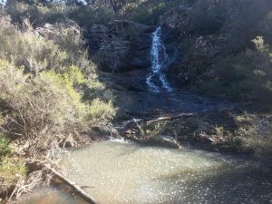
Yes, it was tough countryside – either steep and rocky, else covered with waist-high bracken and fallen trees. The views around Jocks Creek valley were special on Sunday morning, and I wish we’d seen the quoll in the tree, salivating for that dead pig near #68
You didn’t mention the Radio checkpoints – that teams need to visit at least one checkpoint (Alpha, Bravo or Charlie) each day. Here’s another difference from rogaining, because those controls tend to have 20-50 people camped by a big fire, with a bunch of high-viz 4WD vehicles and tents deep in the bush – you can see and/or hear them from 1-2 kilometres, though they’re usually only worth 20-30 points
The NavShield is not a rogaine. Yeah, it’s got a “rogaine” category but that’s just to expand entrant numbers, maintain friendship between BWRS & NSWRA, and allow David and Ronnie to get all the controls. (BTW I heard they slept in Saturday morning and didn’t bother starting with the main pack. Maybe they are starting to get the right attitude)
The NavShield is a bushwalk with a few navigational and many physical challenges. With that mission statement the main priority is firstly to select your campsite on the course. We picked Jocks Creek as the most likely water supply, and our entire day was designed to get us there at, or just after, dark. That does mean a larger backpack with tent, and sleeping gear for mid-winter, and you need to carry nourishment. For dinner I chose a Coopers Green, cheese and crackers, tom yum soup, spaghetti bolognaise and a fresh fruit compote. The apple crumble remained untouched and excessive because we’d eaten so well, however the Bundy rum was a welcome nightcap as we settled into our cosy beds for the night. It was easy to forget the 200m climb waiting at first light, though that effort was compensated at the top of the ridge by a hearty cup of tea with a bacon and cheese roll
NavShield – a good excuse to explore new (wild) countryside and spend time in the bush