After 20 years rogaining I am finally putting pen to paper on my first ever ‘blog’ to congratulate the organisers/setters of the NSW Championship held last weekend at Capertee National Park.
The weather was perfect, warm but not hot, and apart from the occasional spikey acacia and blackberry bush the forests understory allowed easy travel. Occasionally needed to scramble up steep slopes but nothing overly difficult The creeks were also relatively fast travel and we avoided wet feet crossing the Capertee River.
The course required careful navigation with controls generally set on subtle features.
The Australasian Champs held at the same location in 2015 had controls located on creeks or ridge/spur lines providing relatively easy navigation. The 2024 map, generated from LiDAR date sets, provided more accurate detail allowing the setters to place controls on more subtle features often with no obvious attack point thus requiring careful navigation.

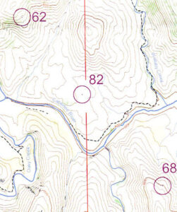
With the mantra of ‘no mistakes’, Ted and I managed to find every control we attempted. The high point was finding Control 82 at night. The description was ‘The gully’ but we would call it, in hindsight, at best a slight depression. We were careful on picking a line of attack and pace counted until convinced we had overshot the control we turned back on the same line and every 25 metres separated and walked laterally in the opposite direction for 50 m. Our second traverse located the control.

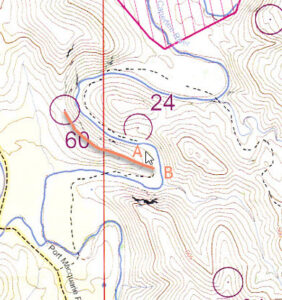
Control 24 should have been easy to locate in daylight but we made an embarrassingly basic navigation mistake. From Control 60 we followed the spur down to the Capertee River. We thought we were just east of the control at the obvious 90 degree bend in the river at A. In fact we were at B at the next 90 degree bend. The creek leaving the river at the bend should have alerted us to our error. We finally orientated our map showing our 90 degree error. Normally I would automatically check the compass bearing on a creek or river line – but this was too easy!
The event was very well organised, the map top quality and the setting by Andrew and Tony one of the best I have experienced. Well done everyone involved in the event.
Thanks to all the volunteers who organized and ran this fantastic weekend of rogaining. What a magnificent part of the world to visit.
Here are some thoughts about participating in a 24 hour rogaine from someone who has not previously completed a rogaine longer than 6 hours:
• With no experience of an event of this duration, our planning was based on a conservative outing: noon to 8 pm on Saturday and then hope that we could back up and do 6 am to noon on Sunday. A target of 14 hours walking. We really had no idea what pace we could do and so planning a route was tricky.
• The terrain wasn’t as severe as we anticipated, lots of ups and downs but not as dense as feared, which meant that we could keep moving at a reasonable plod.
• We didn’t feel the need to hurry like we do in our usual 6 hour event. This meant two things: we could enjoy the countryside more; and we could take a little more time to make sure our navigation was accurate.
• Because we were taking extra care with navigation, and as the map was so accurate, we were able to hit controls with good precision.
• With limited experience, we were worried about navigating at night, so we selected controls closer to roads and utilised the tracks as much as possible. In the end, we stayed out until 9 pm and enjoyed the experience.
• Our favourite parts of the course were along the rivers and creeks, particularly Oaky Creek and also when we travelled from Control 33 along the Capertee River to Control 65.
• It was fantastic to see so many people enjoying the course. (And cool to see the experienced/competent participants zing past.)
Thanks again to all.
Steve,
I didn’t compete but hung and retrieved. I really enjoyed the walk up and down Oaky creek and also walking Ulumbra creek between 61 and W2. It reminded my of walking down the Cox’s or the Kowmung approx 40 years ago when there were cows roaming the rivers and remnant farm trails. I suspect that if we go back to Capertee in 10 years time it might be quite a different experience.
Chris