I’ll remember the “Kariong up the Coast” Autumngaine for some time to come. The event was remarkable for several reasons.
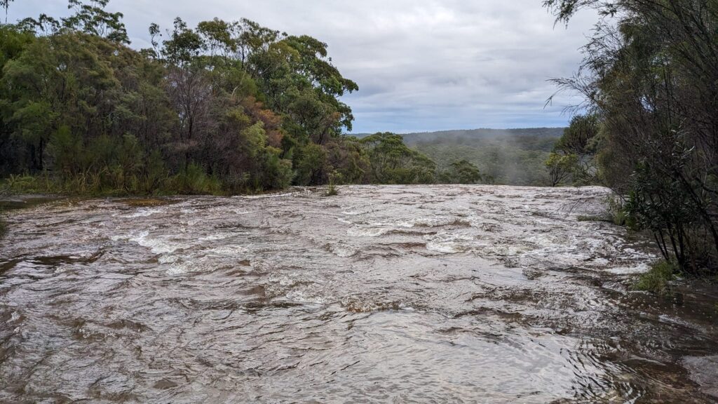
The obvious remarkable point was the weather. The forecast was not good at all. The last forecast I saw was up to 45mms of rain and a significant portion of this falling during the event. This is a nightmare for organisers who need to do the best they can to ensure that we get home safely to loved ones. The creeks around Kariong have a fairly short catchment which means they can rise and fall quickly. In this case, this meant early morning check of critical streams and the decision made to cut out the, possibly dangerous, crossing on Kariong Creek.
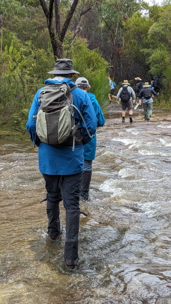
My team mate David and I chose to maximise the fun by competing in the 12 hour event. The 12 hour event started and finished in rain, but the rest of the day was perfect for rogaining. It was cool but not cold and if you kept going you were probably comfortably warm for the entire event.
For the first few hours almost every track had a stream flowing down it and on many occasions you were putting your feet into muddy water not really knowing how deep it was going.
I had rogained at Kariong previously, and one thing I remember from that experience is that you do not go off track unless you have good reason to. There is a lot of really thick scrub off track and it is very slow and not much fun. Well done to the course setters for maximizing off track controls in areas where you were not subjected to fight scrub.
I really liked the inclusion of a 130 point control on the course and the run from 92, through 75 to 130 and then back to the track was a classic bit of rogaining. David and I completed this traverse pretty efficiently. I would not have liked to do these controls in the dark, in fact it would have been madness to do so.
I also really enjoyed the track out to the knoll that was control 104. If you stitched them together just right you could walk the kilometre to this control and back by walking exclusively over open bare rock, which was quite good fun and quite different to the fight scrub in other parts of the course.
I had an exciting few minutes when, about half an hour into the event I slipped on a muddy track and I dropped my compass. Before I could react, my compass washed down the track into a substantial and murky pond of 1 metre deep water. I spent the next 5 minutes grovelling thigh deep pulling out debris from the bottom in the hope that I would also pull out my compass. Eventually my efforts were rewarded and my compass came out with a handful of leaf litter. I always carry a spare compass, but this particular, was my favourite, so it was worth the rescue attempt.
The next bit of excitement we had was when David started to slip off a rock with a reasonable exposure factor. The fall wouldn’t have killed him, but it probably would have been painful. David managed to avoid the fall by deftly leaping onto the next rock just before gravity had its way with him. The only problem was that having defied gravity, momentum took control and he was about to fall off the next rock which had a similar exposure factor. Once again David leapt to yet another rock and this time managed to also grab a dodgy tree branch in order to arrest his momentum before a 4th and much less certain leap was required. Fortunately, David survived the experience without even a scratch, but his adrenalin must have been pumping for the next couple of controls.
Kudos to anyone who didn’t fall over at some stage during yesterday’s rogaine. If you didn’t fall over at least once you either have amazing balance or you were going too slowly. Some of the mud on the tracks was like ice skating. In fact, I realized about 10 mins into the event that while my trail running shoes are great for rocks they were not great on mud as they needed a more aggressive, and less worn, tread pattern.
One of the nice features of the course is that it included a control at the the peak of Mt Wondabyne. If you do not know Mt Wondabyne it has great views from the top that span from Pittwater through to the Mt Yengo in the north. Mt Wondabye is also very distinctive as you drive down the road from Gosford to Sydney. It’s also nice because most of the climb to the top is pretty gradual so you can get to the summit cairn without breaking much of sweat. Having said the views were great, David and I were on a mission and I don’t think either of us paused to take them in as we bagged the 100 pointer at the trig point on top. Both David and I have been up Mt Wondabyne a couple if times before, so this was no sightseeing trip.
The next thing to note about yesterday’s rogaine is that because Kariong Creek was flooded there was no loop course available. David and I decided, as many of the 12 hour competitors did, to take almost every control to the south east and then had a long walk along a fire trail back to the Hash House in the dark before starting another loop. We walked 11kms in the dark between points and I am not sure we event exchanged more than 5 words in that time. It was head down and survive. We were both very tired and bored with the trudge which was only broken by saying g’day to other teams as we passed each other. At least it was relatively flat and required little concentration.
The rain had its last laugh for the 12 hour competitors as it started to rain quite heavily during the last hour or so and at one point I could not see much with my headlight because the light was being reflected by the rain drops.
Special praise go to the organising team lead by Robin and John Cameron. Organising a rogaine is a difficult job and the uncertain weather conditions and last-minute map alterations add an extra element of stress. One of the final bits of drama yesterday, was the top car park. The road up to the top car park looked like it had a good gravel surface but underneath there was a whole heap of mud that got exposed with use in the rain. I think a number of cars had to be pulled out and one difficult extraction was completed at 2am to cheers all around.
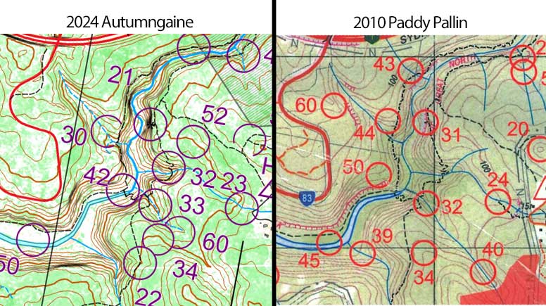
I should also mention the quality of the map yesterday. The bush had been very accurately mapped and if it was dark green on the map you could expect slow progress. The fact that he vegetation marked on the map was pretty accurate really helped with route choice and choice of attack points. I was also impressed by the accuracy of the bare rock platform as represented on the map. This is really the next evolution in map making for NSW Rogaining and a far cry from using a copy of the off the shelf NSW Topo maps.
Thanks to everyone involved for putting this event on and if you were 1 of the 5 miilion or so people in Sydney who didn’t attend yesterday’s event, well you missed out on a good experience.