The Socialgaine was developed to give the regular rogainer a different perspective on the environment. ¼ way between the, all urbane Metrogaine and the largely bush Rogaine. You can go all out and sprint for the 6 hours, or perhaps sip a leisurely coffee at a conveniently located checkpoint coffee house, or slip into the ocean for a refreshing dip, or laze on a large rock shelf at the top of a summit taking in the panoramic views while chatting to your companions, while warmed by the sun at the same time as cooled by the sea breeze. It seems to me a delightful way to renew your feeling of oneness with paradise. For me when I hear paradise described I recognise the east coast of Australia. If you live in paradise why not enjoy the facilities, they were put here for our convenience!
This Socialgaine starts and finishes at the hash house at the park and children’s playground behind the Umina Surf Club House. A most pleasant place to be. I was particularly pleased to see the selection of “adventure” playground equipment, a flying fox to slide out along, a large network of ropes to represent anything you would imagine from sailing ship with masts, to jungle, to trampoline, to skyway, to ……..
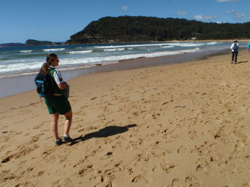
We arrived at about 7:30 on a now beautiful sunny day (after the overcast drizzle of yesterday) and collected the map and instructions, so we could plot out a course. This is Eowyns first Rogaine, so it was pleasing to see that she suggested the same route that interested me. I prefer the scenic, interesting, challenging, rather than the highest score. I find rogaining a great way to explore a section of landscape in a most unusual way. At 9:30 Eowyn grabbed our control card from the “clothes line”, (few rogaines other than Navshield start this way nowadays). And we were on our way down to walk along the Umina Beach for {Check Point 30, a sign beside the beach}, {CP 20, a survey marker at the headland}, {CP 21, a sign}. Very pleasant walking with the sun tempered by the cool sea breeze and stunning scenery, Broken Bay sea stretching out to the Pacific Ocean beyond, bounded by the rocky headlands, with the forested hills behind, many sailing craft on the water. Such a delightful day many people enjoying the beach, the small surf, or out strolling, every where a grin or a laugh.
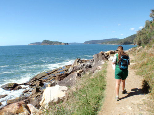
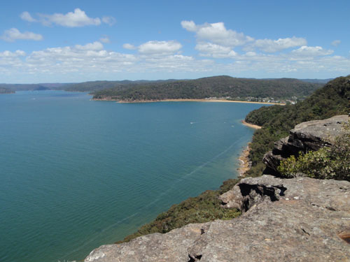
Onward, enjoying even more, Pearl Beach to {CP 31, the sign}. As the song said “sign, sign, every where a sign”. Even that sentiment can’t prevent enjoyment, just ignore the sign:). Around the headland by way of the ocean rock platform to {CP 45, the survey mark}. Our way inland now, along delightfully named Crystal Avenue. Eowyn shows she is more alert than me, as she takes the side Parks Service road. Someone had drawn a line to indicate our intended route and I assumed it was a track :~). {CP 60, the rock shelf on the spur 40m from the track}. We did chat to the flushed competitors who had just scrambled up the much steeper direct route, good choice Eowyn. Still on the track up to {CP 80, the lookout}. Great location for a morning snack while we look south over Broken Bay, past all the racing yachts, to the forests of Kuring-gai Chase, then beyond to the skyline of Sydney far to the south.
Eowyn prefers the shorter steeper foot track to the trig point where we a shushed by a couple watching an echidna eating ants, like they should do 🙂 We keep on, using the short section of track shown on the map, to locate the dogleg spur that leads to {CP 50, scenic end of rock outcrop the spur}. A trifle prickly blackened scrub this way. Back to the track and on to Patonga Drive, where we head down the road, carefully dodging the traffic, to collect {CP 35, end of rock platform}. Again a throng of people sitting enjoying the moment, while they re-fuel ready for the next burst of energy.
We have been travelling this remarkable sandstone ridge plateau for a while now absolutely fascinating country. Low but prickly scrub, many oddly contorted rocky outcrops and extensive rock platforms, many with castellated like paving and every which way you look magnificent scenery. Add the weather and all the smiling people we pass – heaven.
The obvious way onto {CP 33, north side of rock outcrop}, is to take the bush track rather than chance the tar Patonga road again. And a pleasant way to go it is. Only a short walk to {CP 42, a knoll}. I need to explained the nomenclature of rogaining:- when a location is a feature shown on the map it is referred to as “the”, knoll, summit, watercourse, etc., if a feature can be inferred from the map (by a canny reader) it is referred to as “a” whatever. As I’m pointing out “the” knoll and the probable “a” knoll to Eowyn I see the orange and yellow control flag fluttering in the breeze, well that’s easy then :-).
We wander on along this easy walking gently undulating trail to a track junction, where we will go one way for {CP 71, the watercourse, to cool your feet}, or the other for {CP100, the summit}. On the way we passed a man, dressed in an all black running suit, he does not look in a good way and seems partly delirious, but he just keeps going. It seems that there is a 100km and 100 mile race on the Great North Walk today going from Teralba down to Patonga.
The track junction with handy tall shady trees make a great spot to stop and re-energise, and chat to the passing throng. While munching Mars Bars Eowyn was studying the map and suggested a change of plan for more points. Follow the spur from here to CP 100 then return the same way before picking up CP 71 and going on for CP 51 and 70. Great idea well do that.
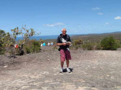
Relatively easy walking on the spur directly to {CP 100, the summit}, is a large rock platform offering great views all round but particularly to the ocean in the east. A large party of competitors was taking the opportunity to sit and enjoy the view and the breeze. I did take a quick look around to see if I could recognise any aboriginal rock engravings, this would be an obvious place. If they were there I couldn’t recognise them. Other areas in Brisbane Waters National Park have extensive areas of aboriginal activities. CP 71 was a nice little rocky creek enough water for a drink from a small pool, but I would have only been able to cool the soles of my feet, bit at a time :-). Then the short hop, back to the main track and then north to where the spur to CP51 and CP 70 starts.
Eowyn thinks that may be an easy way and I think there may even be some sort of track to link with the track shown further up. We glance at the shortest way up to {CP 51, the spur} as we pass, but the steepness, combined with the thick prickly scrub easily dissuades us wimps. There is a marked trail up the spur orange surveyors tape, but the scrub is relatively easy on the top of these ridges and spurs, anyway. Not sure how much actual navigation we did going up here, but I had just stopped momentarily to read the map when Eowyn “here it is”. I suppose you don’t really need to concentrate following along a line feature. The landscape along this ridge top very pleasing, extensive rock platforms of interesting rock formations, low coastal scrub of fascinating variety with lots of flowers. As with most of the course magnificent views in all directions. {CP 70, the saddle}, is just round a dog leg in the ridge, again we were just walking rather than navigating and again I had just stopped to interrogate the map when “here it is” from Eowyn :-).
Just a short section of bush track from here down a steeper spur into the urban area below. All street walking from now on. {CP 36, which bus route goes up the Rampart (st.)?} Easy the utilities pole at the top of the street has the sign, we briefly thought of taking a short cut but the steep terrain deterred us and we went the long easy way (wimps). CP 25, 24 and 23, aren’t much of a challenge and we register back in at 3:27, three minutes to spare.
All to do now total up our score, get someone to check our addition, hand in and then get into the welcome food and drink at the Hash House. Very pleasant to chat with all the smiling people, while we munched on salad and sausage sandwiches, sipping juice, or tea, or coffee, as was your taste.
A very pleasing day, thank you Eowyn for making it so. Congratulations to Eowyn the score of 810 points very credible for a first timer, dragging a stumbley old codger around as a handicap. Thank you and congratulations to the organisers and course setters for a brilliant event in a very picturesque location. Till next time. © Copy Right Dug Floyd November 2012.